Guidance for Developers: A guide to working with Great British Railways on Town Planning and level crossing matters
A guide to working with Great British Railways on Town Planning and level crossing matters – October 2026
Jump to
Introduction
Network Rail manages one of the largest and busiest rail networks in Europe. Development proposals can change how the railway is used, how it interfaces with surrounding land, and the level of risk to both the public and railway operations. The planning system therefore plays a critical role in identifying and managing these risks before development is permitted.
This guidance sets out Network Rail’s approach to engaging in the planning system where development proposals may affect the operational railway. While the primary focus is on level crossings, development can also give rise to a wider range of safety, operational and asset‑related impacts which Network Rail must consider.
It is intended to help developers, promoters and their professional advisers understand how we consider applications, the information we require, and how to engage with us effectively.
This document complements national planning policy and should be read alongside the National Planning Policy Framework and relevant planning legislation and other material considerations, including policies relating to public rights of way, active travel, accessibility and public safety. In some circumstances these objectives may require careful balancing through the planning process.
Network Rail’s role in planning
When Network Rail will be consulted
Network Rail is a statutory consultee where development is:
- Within 10 metres of the railway; or
- Likely to result in a material increase in the volume of traffic using a level crossing; or
- Likely to result in a material change in the character of traffic using a level crossing.
Network Rail is routinely consulted on development proposals that are adjacent to or may otherwise affect railway land, structures or operations, including railway stations.
Network Rail is responsible for managing railway safety risks, under licence from the Office of Road and Rail (ORR), and ensuring that risks are controlled so far as is reasonably practicable (SFAIRP). In responding to planning consultations, Network Rail must consider both existing conditions and how proposed development could alter the way the railway operates along with any changes to risk over time.
Our role in the planning system is not to determine the acceptability of development in land‑use terms, but to provide technical advice to Local Planning Authorities (LPAs) on whether proposals would introduce or increase risks to the operational railway.
Network Rail’s Standing Advice Matrix (as provided at Appendix 1) is used to identify when development is likely to affect a level crossing and whether consultation with Network Rail (and in some cases the Office of Rail and Road) is required.
The Matrix considers:
- Proximity of development to a level crossing;
- Scale and type of development;
- Existing crossing type and usage; and
- Whether development introduces new users or increases use.
Developers and LPAs should review the Matrix at an early stage and assume consultation will be required where a site is within 10 metres of the railway or relies on, or contributes users towards, a level crossing.
Crossing Type
Railway level crossings can be broadly grouped by who is permitted to use them and how they are protected. Somer crossings are public, forming part of the public highway network or public rights of way, whilst others are private crossings that provide access to private land, farms or businesses and are only intended for authorised users. Crossing may accommodate different types of users, including vehicular, footpath crossings, and bridleway crossings.
Level crossings are also classified as either active or passive. Active crossings provide positive warnings of approaching trains through equipment such as barriers, gates, miniature stop lights, audible alarms of road traffic signals. Passive crossings rely primarily on users looking and listening for approaching trains and making their own judgement that it is safe to cross, although some may include telephones or warning signs to assist users. The level of protection provided varies according to the type of crossing, the volume and nature of users, train frequency and speed, and the risks present at each location.
What can impact a level crossing
Developments affecting level crossings
Development can affect level crossings in a variety of ways. These are set out in Appendix 2 and include:
- Increased use
- Introduction of vulnerable users such as children, dog walkers and mobility‑impaired users
- Creation of new desire lines to schools, public open space or countryside
- Increased recreational walking
- Construction traffic using or affecting the crossing
- Changes affecting sighting, audibility or user behaviour
Small numerical increases can result in a disproportionate increase in risk, particularly at footpath and user-worked crossings. Additionally, the qualitative risk may increase. Even where there exist full barrier public road level crossings, generally considered to have risk that is As Low As Reasonably Practicable for a road (short of providing a bridge), that would continue to remain appropriate for the volume of traffic forecast, the effect of barrier downtimes; congestion can of course become more significant as traffic movements increase. This can lead to poor driver behaviour (e.g. running red lights), frustration, pollution from queuing traffic, noise to nearby residents, and congestion in the wider area. It is therefore desirable to avoid developing areas where the only/primary access is via a road level crossing, unless a bridge will be provided to replace the level crossing. Where a bridge is required, it will often be possible to use a Grampian condition, allowing part of the development to be occupied before a bridge is required to be available for public use. New road bridges are expected to be vested in the highway authority.
Level Crossing Narrative Risk Assessment
What we mean
Network Rail manages level crossing risk using the All-Level Crossing Risk Model (ALCRM) supported by a Narrative Risk Assessment (NRA) prepared by a competent Level Crossing Manager. Appendix 3 provides and explanation of how ALCRM and the scores it provides.
ALCRM provides a quantitative assessment of:
- Risk Per Traverse (risk to a typical user); and
- Collective Risk (overall harm expressed as Fatalities and Weighted Injuries).
However, ALCRM cannot fully capture changes in user behaviour. The NRA therefore considers qualitative factors, including:
- Existing and predicted users of the crossing
- Vulnerable user groups
- Train frequency, speed and operational characteristics
- Incident and misuse history
- Behavioural changes arising from development
- Short, medium and long‑term mitigation options
- Whether risks remain controlled so far as is reasonably practicable (SFAIRP)
Developers are not expected to prepare NRA, but the information they submit must be sufficient to allow Network Rail to undertake its assessment efficiently.
Network Rail may undertake a Development Impact Assessment (DIA) for development close to a level crossing to consider the impact fully in the context of adopted Policy, material considerations and level crossing safety risk.
For information about all our level crossings including type, location and risk assessments please visit Active level crossings. Please note: We continually reassess level crossings so published versions of NRAs may not always be the latest available. Please engage with Network Rail early to obtain the latest details.
Network Rail undertakes a NRA on all level crossings this information can be provided. In most circumstances to measure the current risk a nine-day census would be required.
A nine-day census is the industry-standard method for assessing level crossing usage, offering superior accuracy over shorter counts by capturing both weekday and weekend traffic, including potential weekend peaks. These surveys are often conducted via mobile CCTV cameras to monitor user types and behaviours for risk assessment.
- Methodology: Typically involves deploying automatic cameras to record 24/7, providing data to identify, classify, and report on vehicle and pedestrian traffic over a full 9-day period (usually spanning two weekends).
- Purpose: The data helps identify peak times, identify vulnerable users (pedestrians, cyclists, equestrians), and feeds directly into ALCRM to ensure safety and compliance.
- Why Nine Days? This duration is chosen to avoid the unreliability of a “quick census,” which can be heavily skewed by weather, school holidays, or local events, providing a more reliable average daily usage.
- Analysis: Often, the footage is analysed by specialists to create a detailed breakdown of user numbers and types.
Estimating level crossing users
Why standard transport methods are often unsuitable
Whilst TRICS (Trip Rate Information Computer System) is widely accepted as an appropriate tool for estimating vehicular trip generation associated with new development, and we are content for it to be used to assess the impact of development on vehicular use of level crossings, its application to pedestrian movements is not considered robust. This is because TRICS is primarily designed around vehicular patterns and commuting behaviour, and does not adequately capture how pedestrians move through their local environment.
Pedestrian movements are inherently more variable and are strongly influenced by factors such as proximity to the crossing, the availability and convenience of alternative routes, and the relative attractiveness or desirability of those routes. As such, a more location specific approach is required to assess pedestrian use accurately, consistent with the methodology typically applied by Network Rail when considering level crossing usage.
Experience from completed developments demonstrates that standard transport assessment tools frequently under estimate pedestrian use of level crossings, particularly where a crossing provides a convenient or attractive route for day to day or recreational journeys. These approaches often fail to reflect how residents, particularly those in closest proximity, are likely to behave in practice.
This issue has been tested through decision making. In a previous called in appeal for residential development adjacent to an unmanned public footpath level crossing, the scheme was refused primarily on railway safety grounds. The Inspector and Secretary of State concluded that the development would lead to increased use of the crossing and that the developer’s predicted user numbers were not robust or reliable.
A key concern was that the assessment relied on a generic, catchment based approach and did not take sufficient account of site specific factors, including the proximity of the proposed housing to the crossing, the increased likelihood of use by those living closest to it, and the presence of more vulnerable users such as children and teenagers. Increased use was accepted to directly increase risk, including the ALCRM rating, and no safety mitigation was proposed.
The Inspector therefore concluded that, in the absence of measures to improve crossing safety, the development would give rise to an unacceptable risk to future occupiers, contrary to national planning policy, and that public safety considerations outweighed the benefits of the scheme.
Network Rail’s approach
Network Rail uses an evidence-based methodology focused on people, not vehicles, drawing on:
- Office for National Statistics household size data
- Local census and population data (where available)
- Proportions of the population who walk recreationally
- Dog ownership rates
- Proximity to public rights of way and countryside
- Likely vulnerable user groups
- Availability and attractiveness of alternative routes
Developers should:
- Clearly explain and justify assumptions
- Consider both reasonable worst case and lower bound scenarios
- Avoid unsupported discounts to the predicted use as calculated above
- Provide robust evidence of anticipated vehicular movements where these may influence risk, including through Transport Assessments where appropriate
For details on how we calculate non-vehicle users including a worked example please refer to Appendix 3.
Mitigation principles and examples
Mitigation options
Mitigation must seek to reduce or at worst maintain the existing level of risk at a crossing. Measures are considered in accordance with the hierarchy of control, with elimination of risk preferred where reasonably practicable.
Typical mitigation measures provided by the developer include:
- Closure, diversion or extinguishment of a level crossing where reasonably practicable
- Replacement of a level crossing with a bridge or subway
- Upgrades to crossing protection, warning systems or crossing equipment
- Safeguarding land and securing contributions via planning obligations
- Grampian‑style conditions preventing occupation until mitigation is delivered
Signage, user information, warning notices or gating measures alone are unlikely to adequately mitigate an increase in level crossing risk arising from development particularly where development introduces additional users, vulnerable users or change user behaviour. Such measure are generally considreed supplementary controls rather than primary mitigation measures.
Please note: Any mitigation measures proposed must meet the statutory tests for planning obligations, namely that they are:
- Necessary to make the development acceptable in planning terms
- Directly related to the development
- Fairly and reasonably related in scale and kind to the development
Where mitigation involves physical works (such as a footbridge, underpass, or improvements to a level crossing), an appropriate feasibility study would be required to demonstrate that the works are technically, physically and operationally deliverable.
Where mitigation involves the diversion, extinguishment or creation of public right of way, developers should engage at the earlies opportunity with the relevant Public Right of Way Authority, Local Planning Authority, Highway Authority (where relevant) and Network Rail. Such measures may require separate legal processes and approvals, including satisfaction of statutory tests which are independent of the planning application process of any proposed Public Right of Way order. Failure to demonstrate legal, technical and operation deliverability may significantly delay delivery of development.
In some circumstances mitigation may be delivered through a combination of development funding, local authority initiatives, active travel programmes or other third-party funding mechanisms. Opportunities will be considered on a case-by-case basis but should not be assumed.
Suggested Grampian condition set out below; Examples of where this type of condition has been used can be found in Appendix 6.
No occupation shall commence until an application for an order to authorise the stopping up and/or diversion of the relevant public right of way has been submitted to the Council under Section 257 of the Town and Country Planning Act 1990. The development shall not be occupied until:
- the order made pursuant to the relevant application has been confirmed by the Council or Secretary of State) as applicable; or
- The Secretary of State, having considered the merits of the application, decides not to confirm the order authorising the stopping up and/or diversion of the footpath if it is not considered necessary.
Upon any confirmed diversion and stopping up order coming into force, the new footpath route shall be fully completed prior to occupation of the relevant part of the development.
Other railway matters considered by Network Rail
While level crossings are a key focus of this guidance, Network Rail must also consider a wider range of issues where development has the potential to affect the safety, operation and integrity of the operational railway. These matters commonly arise in planning consultations and are summarised below.
Boundary treatment and trespass prevention
- Adequacy of boundary fencing where development adjoins the railway
- Increased risk of trespass arising from residential layouts or new land uses
- Protection of children’s play areas, sports pitches and public open space
Asset protection and construction impacts
- Foundations, excavations or earthworks close to railway land, embankments or structures
- Scaffolding, cranes or plant that could oversail or fall onto the railway
- Demolition or refurbishment works near the operational railway
- Vibration impacts from piling or vibro‑compaction machinery
Drainage, water and ground stability
- Surface water drainage, soakaways or water features that could discharge towards the railway
- Changes in ground levels that could destabilise embankments or cuttings
- Protection of existing railway drainage systems
Trees and landscaping
- Risks posed by trees close to the railway, including fall‑over, leaf‑fall and interference with overhead lines
- Suitability of species, planting distances and long‑term management
- Avoidance of landscaping that compromises boundary fencing or access
Lighting, noise and amenity
- External lighting affecting signal sighting or train driver visibility
- Dazzle from vehicle headlights
- Noise and vibration impacts arising from the railway, including future changes in operations
Access, bridges and highways interaction
- Maintenance of access routes required for railway operations and emergencies
- Increased risk of bridge strikes where development generates additional traffic
- Abnormal load routes affecting railway bridges and structures
Where these matters arise, Network Rail may recommend planning conditions, planning obligations or asset protection agreements. Early engagement is strongly encouraged to ensure these issues are identified and addressed alongside level crossing patterns. We have a standard set of conditions which can be found in Appendix 5.
Engaging with Network Rail – early engagement and pre-application advice
Why early engagement matters
Early discussions help to:
- Identify risk early
- Agree information requirements
- Explore realistic mitigation
- Reduce delay at application stage
What to provide at pre‑application stage:
- A site location plan showing nearby railway infrastructure, including level crossings
- Explanation of pedestrian and vehicular connectivity
- Initial estimates of level crossing use
- Identification of vulnerable user groups
- Emerging mitigation proposals
- Details of any works proposed close to the railway boundary
Key contacts
Developers should engage via the relevant Network Rail Route Town Planning team, typically through the local planning authority consultation process or by requesting pre‑application engagement. There is no fee for pre-application advice.
Contact details are available below and via the Network Rail website or through local planning authorities.
Network Rail Town Planning’s contact details are as follows:
- Southern: TownPlanningSouthern@networkrail.co.uk
- Wales and Western: TownPlanningWestern@networkrail.co.uk
- Eastern: TownPlanningAnglia@networkrail.co.uk
- North West and Central: TownPlanningNWC@networkrail.co.uk
- Scotland: TownPlanningScotland@networkrail.co.uk
Engaging with plan-making and the Railway
Summary of Network Rail’s Approach
Local Plans and Spatial Development Strategies play a crucial role in guiding sustainable growth. Early engagement with the railway during plan preparation is strongly encouraged to ensure that land‑use and transport considerations are properly integrated and that development makes best use of existing and planned rail infrastructure.
A robust evidence base should inform plan‑making, with a focus on reducing the need to travel, minimising journey lengths, and maximising opportunities for walking, cycling and public transport, in line with national transport guidance. Collaboration at this stage can help support net zero carbon objectives and reduce adverse environmental, operational and economic impacts on the railway.
Development should be directed to locations that are, or can be made, sustainable and well connected by public transport. Early engagement enables the identification of suitable locations that support rail capacity, encourage modal shift, and align with wider social, health and economic objectives.
Where site‑specific allocations are proposed, the potential impacts on the railway should be considered both individually and cumulatively, including effects on stations, level crossings, safety, noise, lighting and amenity. Where necessary, mitigation and infrastructure requirements should be identified, alongside appropriate funding mechanisms for any improvements to the railway network.
When formally consulted on plan documents, the railway will provide advice on safety and operational impacts, infrastructure requirements, and the suitability of proposed policies and allocations. Plans should also recognise the importance of safeguarding existing and future rail freight facilities.
Network Rail works collaboratively with Public Right of Way Authorities and representative bodies through the ADEPT/IPROW/Network Rail Memorandum of Understanding (MoU). ADEPT (the Association of Directors of Environment, Economy, Planning and Transport) represents local authority services responsible for highways, transport and countryside access, whilst IPROW (the Institute of Public Rights of Way and Access Management) represents professionals involved in the management of Public Rights of Way and access networks. The MoU provides a framework for cooperation and dialogue between these organisation and Network Rail on matters where public access and railway safety intersect, including the management of level crossings, Public Rights of Way, and the promotion of safe and sustainable access. Developers should be aware that this collaborative approach supports early engagement and joint working between relevant stakeholders when considering proposals that may affect Public Rights of Way crossing the railway.
Appendix 1 – The Standing Advice Matrix
This Standing Advice will give guidance on when the Local Planning Authority (LPA) should consult Network Rail and/or the Office of Rail and Road
|
Development Proposed
|
Within 10 metres of railway land*
|
Development increasing the use, altering the type of users or altering the surrounding environment of a Level Crossing**
|
|---|---|---|
|
Householder development and alteration |
Consult NR |
May need to Consult NR and ORR (see Appendix 1) |
|
Changes of use with no physical changes |
No Consultation |
May need to Consult NR and ORR (see Appendix 1) |
|
Changes of use including physical changes to the building or land |
Consult NR |
May need to Consult NR and ORR (see Appendix 1) |
|
Operational Development |
Consult NR |
May need to Consult NR and ORR (see Appendix 1) |
* Article 16, Part 3, The Town and Country Planning (Development Management Procedure) (England) Order 2015
“Publicity for applications for planning permission within 10 metres of relevant railway land
16.— (1) This article applies where the development to which the application relates is situated within 10 metres of relevant railway land.
(2) The local planning authority must, except where paragraph (3) applies, publicise an application for planning permission by serving requisite notice on any infrastructure manager of relevant railway land.
(3) Where an infrastructure manager has instructed the local planning authority in writing that they do not require notification in relation to a particular description of development, type of building operation or in relation to specified sites or geographical areas (“the instruction”), the local planning authority is not required to notify that infrastructure manager.
(4) The infrastructure manager may withdraw the instruction at any time by notifying the local planning authority in writing.
(5) In paragraph (2) “requisite notice” means a notice in the appropriate form as set out in Schedule 3 or in a form substantially to the same effect.”
** Para (J), Schedule 4 of The Town and Country Planning (Development Management Procedure) (England) Order 2015
“Development which is likely to result in a material increase in the volume or a material change in the character of traffic using a level crossing over a railway”
Consultees – “The operator (Network Rail) of the network which includes or consists of the railway in question, and the Secretary of State for Transport (Officer of Rail and Road)”
Appendix 2 – What can impact a level crossing
Network Rail have a legal duty to assess, manage and control the risk at level crossings. Level crossings are assessed at a frequency that is based on the level of risk a crossing poses. The assessment frequency ranges from 1¼ to 3¼ years. The All Level Crossing Risk Model (ALCRM) is used to provide a risk rating and is explained in detail below.
We improve safety by managing and mitigating the risk at crossings. Including ensuring that any new development does not increase the risk.
Impacts of third-party planning proposals on level crossings:
a) Development directly next to a level crossing may result in impeded views of the crossing or blocking back by vehicles (a queue of vehicles over the crossing).
b) A change in the type of users may increase risk at the crossing e.g. where pedestrians only are allowed to use the level crossing, but a proposal involves allowing cyclists to use the route or the designation as a cycle route.
c) During construction (commercial and residential) where road access to and from the site is via a level crossing or the volume / type of use of a level crossing increases as a result of diverted traffic or of a new highway.
d) Noisy developments might impede pedestrian ability to hear approaching trains at a level crossing, e.g. new airports or new runways / highways / roads.
e) Proposals may interfere with pedestrian and vehicle users’ ability to see level crossing warning signs.
f) Developments for schools, colleges or nurseries may increase the use of minors using a level crossing.
g) Proposals where there are desire lines to restaurants, shops, pubs, schools, colleges may increase the use of the level crossing.
h) Proposals that highlight the use of public rights of way that include crossing the railway at a level crossing, or where the level crossing will form part of a public right of way linking into other public rights of way for greater permeability, may increase the use of the level crossing. i) Development where increased numbers of vulnerable users may access the level crossing (dog‐walkers, push‐chair users, disabled or visually impaired, and the elderly) will likely increase the risk level of the crossing.
Appendix 3 – ALCRM RISK SCORE EXPLANATION
ALCRM calculates the level of risk to individual users (per traverse) and the combined risks for all users, train staff and passengers at level crossings. It provides a consistent and robust quantitative methodology that is supplemented by the local knowledge and professional judgement of risk assessors.
Risk is expressed in fatalities and weighted injuries (FWI). The following values help to explain what this means:
- 1 = 1 fatality per year or 10 major injuries or 200 minor RIDDOR events or 1000 minor non-RIDDOR events
- 0.1 = 20 minor RIDDOR events or 100 minor non-RIDDOR events
- 0.005 = 5 minor non-RIDDOR events
Risk Per Traverse
This is the level of calculated risk to an individual crossing user. It applies to a single traverse of the level crossing or each time the crossing is used by an individual.
Risk per traverse:
- Can be calculated for crossing users, train staff and passengers. Ranking is based on the risk to users only.
- Does not increase with the number of users.
- Is presented as a simplified ranking A to M. A is highest, L is lowest, and M is ‘zero risk’ e.g. temporary closed, dormant or crossings on mothballed lines.
- Allows risks to individuals on a per traverse basis to be assessed even if usage and Collective Risk is low.
- Can help in the prioritisation of risk mitigation and investment in safety.
|
Risk Per Traverse Ranking
|
Probability Upper
|
Probability Lower
|
FWI/traverse Upper
|
FWI/traverse Lower
|
|---|---|---|---|---|
|
A |
1 in 1 |
1 in 500000 |
1 |
0.000002 |
|
B |
1 in 500000 |
1 in 2500000 |
0.000002 |
0.0000004 |
|
C |
1 in 2500000 |
1 in 12500000 |
0.0000004 |
0.00000008 |
|
D |
1 in 12500000 |
1 in 62500000 |
0.00000008 |
0.000000016 |
|
E |
1 in 62500000 |
1 in 125000000 |
0.000000016 |
0.000000008 |
|
F |
1 in 125000000 |
1 in 250000000 |
0.000000008 |
0.000000004 |
|
G |
1 in 250000000 |
1 in 500000000 |
0.000000004 |
0.000000002 |
|
H |
1 in 500000000 |
1 in 1000000000 |
0.000000002 |
0.000000001 |
|
I |
1 in 1000000000 |
1 in 2000000000 |
0.000000001 |
0.0000000005 |
|
J |
1 in 2000000000 |
1 in 5000000000 |
0.0000000005 |
0.0000000002 |
|
K |
1 in 5000000000 |
1 in 10000000000 |
0.0000000002 |
0.0000000001 |
|
L |
1 in 10000000000 |
Greater than 0 |
0.0000000001 |
Greater than 0 |
|
M |
0 | 0 | 0 | 0 |
Collective Risk
This is the total calculated risk for the crossing and includes the risk to users (pedestrian and vehicle), train staff and passengers.
Collective risk:
- Is presented as a simplified ranking 1 to 13. 1 is highest, 12 is lowest, and 13 is ‘zero risk’ e.g. temporary closed, dormant or crossings on mothballed lines.
- Can help in the prioritisation of risk mitigation and investment in safety.
|
Collective Risk Ranking
|
Upper Value (FWI)
|
Lower Value (FW)
|
|---|---|---|
|
1 |
Theoretically infinite |
Greater than 5.00E-02 |
|
2 |
0.050000000 |
0.010000000 |
|
3 |
0.010000000 |
0.005000000 |
|
4 |
0.005000000 |
0.001000000 |
|
5 |
0.001000000 |
0.000500000 |
|
6 |
0.000500000 |
0.000100000 |
|
7 |
0.000100000 |
0.000050000 |
|
8 |
0.000050000 |
0.000010000 |
|
9 |
0.000010000 |
0.000005000 |
|
10 |
0.000005000 |
0.000001000 |
|
11 |
0.000001000 |
0.000000500 |
|
12 |
0.0000005 |
0 |
|
13 |
0.00E+00 |
0.00E+00 |
Appendix 4 – How we calculate users
Method of predicted users at level crossings from new development
** Please note this document will need constant updating. It is correct as at 11/06/24 – author is Lisa Bullock (NR Senior Town Planner)
Guidance note for calculating predicted users (not vehicles)
A spreadsheet is available to accompany this note; please email TownPlanningWestern@networkrail.co.uk and the spreadsheet will be emailed back to you
Future Population
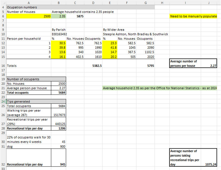
There are several ways of working this figure out and it is recommended that a developer should use all three and then calculate the average:
- Future population can be estimated by reference to data of the Office of National Statistics (ONS). The ONS states that in 2024, the average household in England was home to 2.35 people. (Result found in cell C6)
- This can be broken down locally by number of persons within a household using the Office for National Statistics Census maps, March 2021. By Parish and by County. (Result found in cells D16 for parish and G16 for County/wider area) https://www.ons.gov.uk/census/maps/choropleth/population/household-size/hh-size-5a/1-person-in-household?msoa=E02004666
- Estimated housing mix for the area using the councils monitoring report and the population yield from another council document (this is likely to vary from council to council). (Not included in the spreadsheet, but if there is a report which sets this out for the area it should be able to support your findings)
Vulnerable users
Vulnerable level crossing users can be defined as people who, when compared with typical users:
- Are likely to take an extended time to traverse due to disability or distraction
- Might be at greater risk of harm due to their perception of risk
Defining vulnerability
There are a number of factors that can result in people being at greater risk when using level crossings. These can include but are not limited to:
- Limitations in mobility (take into account not only the ability to walk, but also the ability to turn their bodies or heads and look for oncoming trains)
- Visual or hearing impairment
- Cognitive ability, e.g. making safety related decisions (very young and elderly people are more likely to make poor decisions on the distance and speed of large moving objects such as trains)
- Being encumbered, e.g. crossing with bags, pushchairs, cycles or dogs (consider if dogs are on or off a lead (including the use of extendable versions), and if owners are in charge of more than one dog; it becomes increasingly harder to control multiple animals)
- Inability to comprehend English, i.e. to read signage and / or speak to Signallers
Types of vulnerable users
Vulnerable users can include, but are not limited to:
- People with physical and/or mental disabilities or other impairments; incl. those using mobility scooters
- Young children; unaccompanied or in groups
- Elderly people
- Dog walkers
- Cyclists, e.g. where known not to dismount and considered ‘at risk’
- People carrying heavy bags or large objects, with pushchairs etc.
- Non-English language speakers, e.g. migrant workers 1
Children – categorised as vulnerable users because they are not fully aware of the danger at level crossings. They are unable to process correctly the speed of objects coming towards them.
Older pedestrians (aged 65 or over) – cannot achieve the 1.2 metres per second (m/s) walking speeds assumed in the programming of pedestrian crossings. 2
1 Information taken from Level Crossing Guidance Document – Census Good Practice July 2017 (Section 5.3)
2 Taken from https://publications.parliament.uk/pa/cm201314/cmselect/cmtran/680/68007.htm
How to calculate how many vulnerable users a new development might generate
Children and older population (Not included in the spreadsheet – but you might want to include within your risk assessment or to add context when describing the impacts any change in users might incur)
The average number of children per household is 1.9 (taken from ONS). The ONS also reports that families with depended children is 42%.
The census map can also tell you population split between ages giving you the ability to calculate numbers of the following
- How many residents will be 65 years or over
- How many residents will be aged 14 or under
- How many residents will be aged 15 – 21 years old
Dog walkers (Result found in cell B31)
Statista, an online statistics, market research and business intelligence portal providing data from market and opinion research institutions, reports that (in 2025) 36% of all UK households owned a dog.
Pedestrian Movement
Governments’ official statistics (2022) on average a person will take 267 walking trips over a year and 29% of walking trips are for just walking. Walking and cycling statistics, England: Introduction and main findings – GOV.UK (www.gov.uk) (Result found in cell B28)
The Ramblers Association have undertaken surveys which conclude that 22% of the population walk recreationally for at least 30 minutes in four weeks. (Result found in cell B30)
The above will allow you to calculate the likely number of persons walking trips over a year. If there is no specific destination on the other side of the crossing such as a school, shop, pub etc then the % of just walking trips is relevant. Looking at the Transport Assessment will give you an idea of trip rates for these activities.
A judgement by you on other alternative walking routes and how these will compare to the route over the level crossing is needed. In some locations Local Authorities have produced documents providing an analysis of walking trips. In Oxfordshire they have provided detail of how many walking trips are taken on the PRoW as opposed to other walking trips. Oxfordshire County Council have this detail in the document found in this link Microsoft Word – FINAL DRAFT RoWMP_27October (oxfordshire.gov.uk) and therefore other councils might have a similar type of document which will help with your evidence.
Example below – 2500 dwellings to be built next to a level crossing in Steeple Ashton, North Bradley and Southwick.
Appendix 5 – Standard set of conditions
Network Rail Standing Advice for development within 10m of railway land
Safety
Any works on this land will need to be undertaken following engagement with Asset Protection to determine the interface with Network Rail assets, buried or otherwise and by entering into a Basic Asset Protection Agreement, if required, with a minimum of 3months notice before works start. Initially the outside party should contact ASPRO Network Rail Implementation.
Fencing
If not already in place, the developer/applicant must provide at their expense a suitable trespass proof fence (of at least 1.8m in height) adjacent to Network Rail’s boundary and make provision for its future maintenance and renewal without encroachment upon Network Rail land. As Network Rail is a publicly funded organisation with a regulated remit it would not be reasonable to require Network Rail to fund boundary works, fencing and boundary enhancements necessitated by third party commercial development. Network Rail’s existing fencing / wall must not be removed or damaged and at no point either during construction or after works are completed on site should the foundations of the fencing or wall or any embankment therein be damaged, undermined or compromised in any way. Any vegetation on Network Rail land and within Network Rail’s boundary must also not be disturbed. Network Rail’s Asset Protection Engineer will need to review the fencing to ensure that no works to the foundations undermine or destabilise Network Rail land, or encroach onto Network Rail land.
Drainage
Soakaways / attenuation ponds / septic tanks etc, as a means of storm/surface water disposal must not be constructed near/within 5 metres of Network Rail’s boundary or at any point which could adversely affect the stability of Network Rail’s property/infrastructure. Storm/surface water must not be discharged onto Network Rail’s property or into Network Rail’s culverts or drains. Network Rail’s drainage system(s) are not to be compromised by any work(s). Suitable drainage or other works must be provided and maintained by the Developer to prevent surface water flows or run-off onto Network Rail’s property / infrastructure. Ground levels – if altered, to be such that water flows away from the railway. Drainage does not show up on Buried service checks.
Full details of the drainage plans are to be submitted for acceptance to the Network Rail Asset Protection Engineer. No works are to commence on site on any drainage plans without the acceptance of the Network Rail Asset Protection Engineers: Network Rail has various drainage standards that can be provided Free of Charge should the applicant/developer engage with Network Rail’s Asset Protection Engineers.
Encroachment
The developer/applicant must ensure that their proposal, both during construction and after completion of works on site, does not affect the safety, operation or integrity of the operational railway, Network Rail and its infrastructure or undermine or damage or adversely affect any railway land or structures. There must be no physical encroachment of the proposal onto Network Rail land, no over-sailing into Network Rail airspace and no encroachment of foundations onto Network Rail land and soil. Any future maintenance must be conducted solely within the applicant’s land ownership. Should the applicant require access to Network Rail land then they must seek approval from Network Rail Asset Protection Team. Any unauthorised access to Network Rail land or air-space is an act of trespass and we would remind the council that this is a criminal offence (s55 British Transport Commission Act 1949). Should the applicant be granted access to Network Rail land then they will be liable for all costs incurred in facilitating the proposal.
Ground levels
The developers should be made aware that Network Rail needs to be consulted on any alterations to ground levels. No excavations should be carried out near railway embankments, retaining walls or bridges.
Foundations
Network Rail offers no right of support to the development. Where foundation works penetrate Network Rail’s support zone or ground displacement techniques are used the works will require specific approval and careful monitoring by Network Rail. There should be no additional loading placed on the cutting and no deep continuous excavations parallel to the boundary without prior approval.
Ground disturbance
The works involve disturbing the ground on or adjacent to Network Rail’s land it is likely/possible that the Network Rail and the utility companies have buried services in the area in which there is a need to excavate. Network Rail’s ground disturbance regulations applies. The developer should seek specific advice from Network Rail on any significant raising or lowering of the levels of the site.
Site layout
The applicant must ensure that the construction and subsequent maintenance can be carried out to the proposed development (including any boundary treatment) without affecting the safety of, or encroaching onto Network Rail land and air-space. Network Rail therefore requires a minimum 2 metres gap between the proposal and our boundary fencing for the following reasons:
- To allow for all construction works on site and any future maintenance to be carried out wholly within the applicant’s own land ownership and without encroachment onto Network Rail land and air-space.
- To ensure that should the proposal fail or collapse that it will do so without damaging Network Rail’s boundary treatment or causing damage to the railway (e.g. any embankments, cuttings, any lineside equipment, signals, overhead lines) and to prevent the materials from the development falling into the path of trains.
- To ensure that the proposal (including any boundary treatments) cannot be scaled and thus used as a means of accessing Network Rail land without authorisation.
- To ensure that Network Rail can maintain and renew its boundary treatment, fencing, walls etc
- To ensure that the applicant does not construct their proposal so that any foundations (for walls, buildings etc) do not end up encroaching onto Network Rail land. Any foundations that encroach onto Network Rail land could undermine, de-stabilise or other impact upon the operational railway land, including embankments, cuttings etc.
Piling
Where vibro-compaction/displacement piling plant is to be used in development, details of the use of such machinery and a method statement should be submitted for the approval of Network Rail’s Asset Protection Engineer prior to the commencement of works and the works shall only be carried out in accordance with the approved method statement.
Excavations/earthworks
All excavations / earthworks carried out in the vicinity of Network Rail’s property / structures must be designed and executed such that no interference with the integrity of that property / structure can occur. If temporary compounds are to be located adjacent to the operational railway, these should be included in a method statement for approval by Network Rail Asset Protection.
Demolition
The demolition works on site must be carried out so that they do not endanger the safe operation of the railway, or the stability of the adjoining Network Rail structures and land. The demolition of the existing building, due to its close proximity to the Network Rail boundary, must be carried out in accordance with an agreed method statement. Approval of the method statement must be obtained from the Network Rail Asset Protection Engineer before the development and any demolition works on site can commence.
Plant, scaffolding and cranes
Any scaffold which is to be constructed adjacent to the railway must be erected in such a manner that, at no time will any poles or cranes over-sail or fall onto the railway. All plant and scaffolding must be positioned, that in the event of failure, it will not fall on to Network Rail land.
Access to railway
All roads, paths or ways providing access to any part of the railway undertaker’s land shall be kept open at all times during and after the development.
Children’s play areas/open spaces/amenities
Children’s play areas, open spaces and amenity areas must be protected by a secure fence along the boundary of one of the following kinds, concrete post and panel, iron railing, steel palisade or such other fence approved by the Local Planning Authority acting in consultation with the railway undertaker to a minimum height of 2 metres and the fence should be not able to be climbed.
Tunnels
Network Rail’s Engineer is to approve details of any development works within 15m, measure horizontally, from the outside face of the tunnel extrados with special reference to:
- The type and method of construction of foundations
- Any increase/decrease of loading on the tunnel both temporary and permanent.
- Certified proof that the proposals shall have no detrimental effect upon the tunnel will be necessary.
Any proposal must not interfere with Network Rail’s operational railway and not jeopardise the structural integrity of the tunnel. The above details should be submitted to the Council and only approved in conjunction with Network Rail.
Network Rail will not accept any liability for any settlement, disturbance or damage caused to any development by failure of the tunnel structures nor for any noise or vibration arising from the normal use and/or maintenance of the tunnel. No right of support is given or can be claimed from Network Rails tunnels or railway land.
Noise
Network Rail would remind the council and the applicant of the potential for any noise/ vibration impacts caused by the proximity between the proposed development and the existing railway, which must be assessed in the context of the National Planning Policy Framework (NPPF) and the local planning authority should use conditions as necessary.
The current level of railway usage may be subject to change at any time without prior notification including increased frequency of trains, night time train running and heavy freight trains.
There is also the potential for maintenance works to be carried out on trains, which is undertaken at night and means leaving the trains’ motors running which can lead to increased levels of noise.
We therefore strongly recommend that all future residents are informed of the noise and vibration emanating from the railway, and of potential future increases in railway noise and vibration.
Landscaping
Where trees/shrubs are to be planted adjacent to the railway boundary these shrubs should be positioned at a minimum distance greater than their predicted mature height from the boundary. Certain broad leaf deciduous species should not be planted adjacent to the railway boundary. We would wish to be involved in the approval of any landscaping scheme adjacent to the railway. Where landscaping is proposed as part of an application adjacent to the railway it will be necessary for details of the landscaping to be known and approved to ensure it does not impact upon the railway infrastructure. Any hedge planted adjacent to Network Rail’s boundary fencing for screening purposes should be so placed that when fully grown it does not damage the fencing or provide a means of scaling it. No hedge should prevent Network Rail from maintaining its boundary fence. Lists of trees that are permitted and those that are not are provided below and these should be added to any tree planting conditions:
Permitted:
Birch (Betula), Crab Apple (Malus Sylvestris), Field Maple (Acer Campestre), Bird Cherry (Prunus Padus), Wild Pear (Pyrs Communis), Fir Trees – Pines (Pinus), Hawthorne (Cretaegus), Mountain Ash – Whitebeams (Sorbus), False Acacia (Robinia), Willow Shrubs (Shrubby Salix), Thuja Plicatat “Zebrina”
Not Permitted:
Alder (Alnus Glutinosa), Aspen – Popular (Populus), Beech (Fagus Sylvatica), Wild Cherry (Prunus Avium), Hornbeam (Carpinus Betulus), Small-leaved Lime (Tilia Cordata), Oak (Quercus), Willows (Salix Willow), Sycamore – Norway Maple (Acer), Horse Chestnut (Aesculus Hippocastanum), Sweet Chestnut (Castanea Sativa), London Plane (Platanus Hispanica).
Heaping, dust and litter
It should be noted that because of the nature of the proposals we would not want to see materials piled against our boundary. Items to be heaped on site should be kept away from the boundary an equal distance as the pile is high to avoid the risk of toppling and damaging or breaching our boundary. We also have concerns over the potential for dust clouds and rubbish created from the processing at the site affecting the railway signal sighting. Therefore, adequate measures for preventing dust and rubbish blowing onto Network Rail property are to be in operation.
Lighting (shorter)
Any lighting associated with the development (including vehicle lights) must not interfere with the sighting of signalling apparatus and/or train drivers vision on approaching trains. The location and colour of lights must not give rise to the potential for confusion with the signalling arrangements on the railway.
Vehicle incursion
Where new roads, turning spaces or parking areas are to be situated adjacent to the railway; which is at or below the level of the development, suitable crash barriers or high kerbs should be provided to prevent vehicles accidentally driving or rolling onto the railway or damaging the lineside fencing.
Wind turbines
Network Rail would wish to see such equipment sited so that the lateral distance from railway boundary to foot of mast is greater than height of mast + length of propeller blade. Wind turbulence may be a factor to be considered and the applicant would need to ensure design/position of wind turbine does not present a potential problem for neighbours (railway included). Should the turbines collapse for any reason then the developer should ensure that any fail safe distance will include the wind-turbines potential for topple in the direction of the railway line. Asset Protection Engineering involvement may only be needed when constructing or undertaking maintenance of the wind turbine and then only where such activities presented a potential risk to the operational railway.
Solar panels
We would advise that the provision of any reflective material used in the solar collecting equipment should not interfere with the line of sight of train drivers and the potential for glare or reflection of light from the panels that may impact upon signalling must be eliminated.
Network Rail would expect the applicant to demonstrate that the panels are either not reflective or that appropriate fencing/mitigation or other screening is erected between the railway and the solar panels to avoid this happening.
Former NR land
The development appears to be located on an area of land previously under the ownership of Network Rail. Often these sites are sold and are subject to a demarcation or covenant agreement which may include particular rights in relation to the safe operation of the railway and associated infrastructure. It must be considered when Network Rail has access rights over the development site; access must not be blocked or restricted at any time. The applicant must comply with all post sale covenants in the demarcation agreement and understand the implications this will have on the implementation of this development.
Netting
The applicant must provide suitable ball proof mesh netting for the football pitches. The application must provide details of the netting to the Asset Protection Engineers to ensure that the netting is installed without placing any load bearing weight upon Network Rail land, and to ensure that the pole foundations do not undermine or encroach upon Network Rail land. The netting should be 5m in height to prevent all potential sports equipment i.e. footballs from over-sailing the railway boundary and falling into the path of trains. The applicant must consider the foundations of the netting which could undermine or destabilise Network Rail’s land. Equally, netting erected on land next to the operational railway could topple over in high winds and fall onto Network Rail’s land, onto the path of trains or onto safety critical equipment (e.g. signals, telecoms cabinets) if above the level of the railway.
Party wall
Where works are proposed adjacent to the railway it may be necessary to serve the appropriate notices on Network Rail and their tenants under the Party Wall etc Act 1996. Developers should consult with Network Rail at an early stage of the preparation of details of their development on Party Wall matters.
The applicant is reminded that any works close to the Network Rail boundary, and any excavation works are also covered by the Party Wall Act of 1996. Should any foundations, any excavations or any part of the building encroach onto Network Rail land then the applicant would need to serve notice on Network Rail and they would be liable for the costs. An applicant cannot access Network Rail without permission (via the Asset Protection Team) and in addition to any costs under the Party Wall Act, the applicant would also be liable to all Network Rail site supervision costs whilst works are undertaken. No works in these circumstances are to commence without the approval of the Network Rail Asset Protection Engineer.
Method statements/fail safe/possessions
Method statements may be required to be submitted to Network Rail’s Asset Protection Engineer for prior approval of works commencing on site. Where any works cannot be carried out in a “fail-safe” manner, it will be necessary to restrict those works to periods when the railway is closed to rail traffic i.e “possession” which must be booked via Network Rail’s Asset Protection Engineer and are subject to a minimum prior notice period of booking of 20 weeks. The applicant will be liable for all costs incurred by Network Rail (including all possession costs, site safety supervision, asset protection presence). The applicant is reminded that Network Rail can refuse any third party works that would impact adversely on its infrastructure.
Telecommunications
Much of the national railway network is controlled and operated by its own electronic communications systems, and as such, it is important that any proposals for new telecommunications equipment near to the railway do not interfere with the safe movement of trains. To ensure that Radio Frequency (RF) risks are addressed and mitigated, the Applicant must adhere to Network Rail processes for telecoms clearance (NR standard NR/L2/TEL/3006) before installing new or upgrading an existing radio transmitter within the distance proposed in the planning application, as a means of ensuring that the evidence required under the NPPF is obtained.
Appendix 6 – Grampian condition
Evolution of Railway Safety Grampian Conditions
The wording of railway-related Grampian conditions has evolved over time in response to appeal decisions and legal challenges concerning the closure, diversion or alteration of public rights of way crossing the railway.
Historically, planning conditions often simply required a level crossing to be closed, or a stopping up/diversion order to be secured before occupation of development. However, appeal decisions and case law have highlighted the need for conditions to recognise that the legal process required to stop up or divert a highway is undertaken by a separate decision maker and is outside the direct control of the developer.
In C.A Vasiliou v Secretary of State for Transport and Another 507, the Court of Appeal confirmed that decisions relating to stopping up highways involve a separate statutory process in which the decision maker must consider the impacts on those affected by the extinguishment of rights. The Court recognised that a stopping up order cannot simply be assumed to follow from the grant of planning permission and that the separate consenting process must retain its own independent decision-making function.
More recent Planning Inspectorate decisions have reflected this principle. In the Barnham appeal (APP/C3810/W/21/3273087), the Inspector accepted a Grampian condition requiring a rail crossing extinguishment or diversion order to be made and confirmed before occupation of the development. Importantly, the wording provided flexibility by recognising that the order may result in either diversion or extinguishment of the public right of way and expressly acknowledged that the condition would cease to apply if the relevant authority or Secretary of State refused to confirm the order.
The Inspector specifically addressed the legality of the condition and concluded that it met the relevant planning tests because there was a reasonable prospect of the necessary railway safety works and legal orders being delivered within the lifetime of the permission. The Inspector also noted that the wording had been carefully drafted to reflect the statutory processes under sections 118A and 119A of the Highways Act 1980 and to maintain flexibility regarding the final solution.
The resulting condition stated: “The Development shall not be occupied until a rail crossing (extinguishment or diversion) order has been made and confirmed…” and continued to provide that the condition would not apply where the relevant authority or Secretary of State refused to confirm the order.
This represents a significant evolution from earlier, more prescriptive conditions because it:
- recognises that highway stopping up and diversion orders are separate statutory processes;
- avoids predetermining the outcome of those processes;
- allows flexibility regarding the final form of mitigation (diversion, extinguishment or alternative crossing solution);
- includes a “fallback” provision where the decision maker refuses to confirm the order; and
- demonstrates a reasonable prospect of delivery, consistent with modern case law on Grampian conditions.
Consequently, modern railway safety Grampian conditions are generally drafted to focus on achieving the required safety outcome rather than prescribing a single mechanism, whilst respecting the independence of the separate legal processes needed to implement public rights of way changes.
Examples of the use of the suggested condition
Barnham Station, West Sussex – Appeal Ref APP/C3810/W/21/3273087 – Up to 200 dwellings with associated infrastructure and landscaping on land south of Barnham Station, Barnham, West Sussex. The proposal was refused by Arun District Council but subsequently allowed on appeal by a Planning Inspector appointed by the Secretary of State (Planning Inspectorate) on 5 January 2022.
Condition 28
The Development shall not be occupied until a rail crossing (extinguishment or diversion) order has been made and confirmed in respect of a section of Footpath 323, to include where Footpath 323 crosses operational railway land at both Birch level crossing and West Barnham level crossing, and the relevant section(s) of Footpath 323 has been lawfully extinguished or diverted.
Inspector’s Commentary: The Inspector expressly confirmed that Condition 28 was a Grampian style condition and considered it necessary to address public safety concerns associated with the existing unmanned level crossings. The decision states that occupation of the dwellings would be prevented until an order had been made and confirmed to secure a safe alternative arrangement for Footpath 323.
Reason: To ensure safe and suitable pedestrian connectivity and to address railway safety risks associated with the Birch and West Barnham level crossings before any dwellings are occupied. The Inspector concluded that, subject to this Grampian condition, the development would make appropriate and safe provision for access to local facilities and would not result in an over-reliance on the private car.
Springfield LX – Sedgemoor District Council ref 11/18/00087 – 110 dwellings – land at, Lakeside, Highbridge, Somerset.
Condition 31
i) No development shall commence above DPC Level until a diversion order of the existing footpath Ax32/21 to prevent any public access to the Springfield public railway level crossing (including the erection of signage and fencing prohibiting such access) has been made and confirmed by the LPA or the Secretary of State.
ii) Following satisfaction of i) above none of the dwellings hereby approved shall be occupied until:
the Springfield public railway level crossing has been closed and
in the context of i) above a alternative route (temporary or otherwise) is made available to the written satisfaction of the Local Planning Authority
iii) The agreed diverted route shall be provided in full to adoptable standard and to the written satisfaction of the Local Planning Authority prior to the final occupation of the last dwelling hereby approved.
Reason: To ensure safe pedestrian access within and through the site and alternative sustainable connections in the absence of the existing link in accordance with Policy D13 of the Local Plan.
Dallington Grange, Northampton – Northampton Borough Council ref N/2014/1429 – Up to 3,000 dwellings and associated employment, retail, education, infrastructure, open space and highway works.
Condition 54 (old style of condition; since been adapted following C.A decision)
No occupation of any part of the development shall take place until the footpath diversion order in relation to part of Public Right of Way HW44 as shown on drawing no. P.1053_30 has been made, confirmed and brought into effect.
Reason: In the interests of public safety and to ensure a safe and secure development due to the proximity of the development to a level crossing in accordance with the aims of Policy S10 of the West Northamptonshire Joint Core Strategy.